
Swamp, Meat, Salt
A river chokes on blood, fish choke on water, and a town chokes on resentment. Welcome to Stinkopolis, Worst Smellbourne, for a story about industry, water, and class war.

Map
Use the icon at the top left to toggle which tracks are shown, and “star” the map to save it to your Google Maps.
Transcript
Meat
Liz Crash: A widespread heap of decaying entrails, offal, plucks, and coagulated blood, spread out for a long distance under water, and rising above it at the discharge. The contents of the stomachs, and a host of other products of slaughtering on a large scale, are poured into the river, to be spread up and down as the tide flows… A dead sheep, swollen ready to burst, floats close in shore… the river is red with the mixture of blood it contains.
That’s what a local journalist saw in 1887, right about where I’m standing now, on the west bank of the Maribyrnong River, in Footscray.
I’ve been looking through nineteenth-century local newspaper archives a lot, lately. I’ve been trying to get a better sense of the place I grew up, what it was like here before my family came. Almost all of the old streets are still around, but I kept seeing all these references to a place called Swamp road. There’s no Swamp road in Footscray anymore. I set out to find where it was.
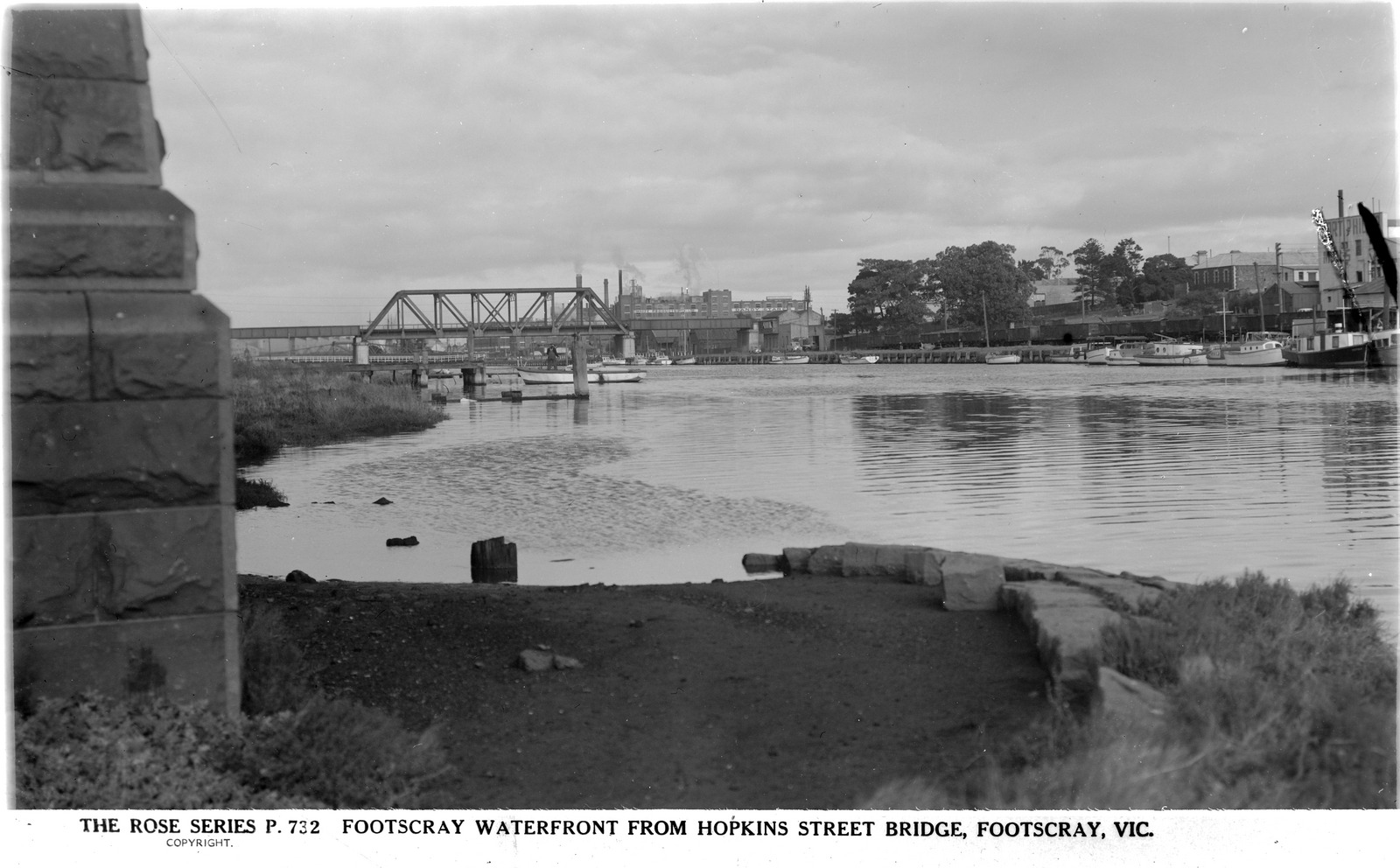
Turns out it’s right about here. It’s now called Dynon road, and you get to it by crossing the Hopkins Street bridge I’m standing under.
But I don’t see any swamps around here.
Turns out there used to be one, a huge one. So what happened to it?
Well, to answer that question, you have to go back to that blood in the water.
That blood was from slaughterhouses further upstream, the first major settler industry in the area. Initially, the land west of the Maribyrnong river wasn’t valued by settlers except as grazing land — it was too flat, too dry, too windy. So the very first European settlers, from the 1830s, were grazers of cattle and sheep. Within a few years there were thousands and thousands of sheep.
The local market was small. The British markets were where the profits were. When there was an economic downturn in the 1840s and the price of wool dropped, it made sense financially to slaughter those sheep and process them into a form that was a bit more stable and could be put on a boat to England. Predominantly, this meant tallow – animal fat, processed into a form that doesn’t easily go rancid.

To process tallow, you boil carcasses until the fat melts and separates from the flesh and the bone. Here’s a journalist describing Raleigh’s boiling-down works a little upstream of here:
We saw 120 sheep cut into pieces, hobnobbing and pirouetting, and making merry together in a fashion strangely at variance with the usual staid character when alive. Heads and trotters came up and went down; rich joints and chops, briskets and necks, ribs and jaw bones, knocked and mauled each other without ceasing, and each part of the 120 sheep seemed to us to join in vigorous protest against the boiling-down process.
After the price of wool rose again, and they stopped boiling down whole sheep, boiling-down works were still around, but they used the scraps from slaughterhouses. There were lots of industries that sprung up around slaughterhouse products and by-products — leather tanning, bone grinding, soap making, fertiliser — but by the time they got their raw materials, it had usually been a couple days since slaughter and they hadn’t been cleaned off. The stench was unbelievable. People complained about it constantly.
It didn’t just stink, it was dangerous, it made people sick. Footscray had a really high rate of infectious disease and mysterious poisonings and stuff like that. The slaughterhouse industries produced blood and fat and rotting dead flesh scraps, for starters, but also stuff like enzyme solutions made of shit, and ammonia solutions made of piss, and formaldehyde, hexavalent chromium, carcinogens by the kilolitre. And all that was dumped straight in the river.
Swamp
It wasn’t their river to trash, of course. The Maribyrnong river and the land around it belongs to the Boon Wurrung and Woi Wurrung people, two of the five language groups in the Kulin nation around Melbourne and surrounding areas. They are still here. But in the nineteenth century, very few people from any Aboriginal nation lived here. One reason was the destruction of their food sources.
Traditionally, the people who lived on the river relied a lot on river food, mussels and fish. A nineteenth-century observer of the Maribyrnong said that they witnessed ‘some small fish that had found their way into the putrid waters were swimming dead or dying on the surface’.
So there were very few fish, and what few were left were not safe to eat.
Water is important to everyone, of course; water is life. But water is also central to Kulin people’s spirituality. The traditional boundaries between each estate were drawn by rivers and creeks and water catchment areas. That land and water has never been theirs to pollute – in Kulin cultures you have a religious duty to protect the integrity of the land and water.
I don’t mean religious as in, it’s very important, I mean literally a religious duty. There’s a Boon Wurrung story about how the bay now called Nairm or Port Philip Bay used to be dry land, until the sea rose up in anger because the people of the land were not meeting their responsibilities to each other and the land, they were overfishing, they weren’t managing eel stocks, they were being careless towards the land and towards each other.
Other Kulin nations have similar stories — everyone agrees that the bay used to be land. And the geologists say the same thing — it was land until sea levels rose, first slowly, thousands of years ago, and then very very fast, about a thousand years ago, breaking through a silt barrier in a flood.
So this is a story about water that shows first of all, the exact location of the sea and river and how they change over time is really important, the kind of thing that you hold onto for at least a thousand years. Secondly, it’s a story where poor management of fish stock is seen as such a profound neglect of your social and spiritual responsibilities that the sea itself will rise up against you.
I wasn’t able to find out exactly what Woi Wurrung or Boon Wurrung people felt about what was happening to the Maribyrnong in the 19th century — the oral histories from that time are really disrupted. But I think it must have felt like the end of the world.
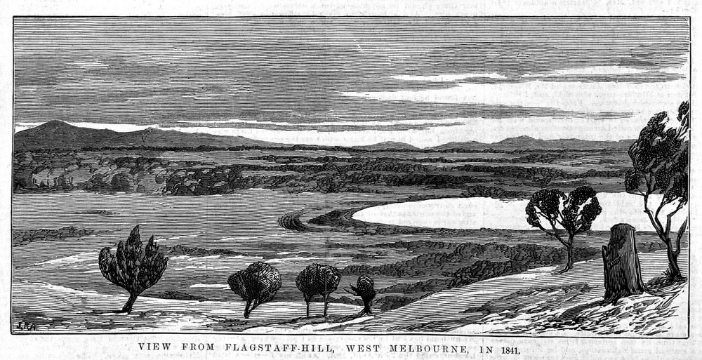
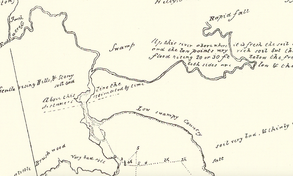
The Maribyrnong flows straight into the sea now. It used to go through a vast wetland first. East of where I’m standing, to the other bank of the river, you can see the Port Melbourne docks. That used to be the Great Melbourne Swamp — the place the Swamp Road ran beside.
In 1841, at high tide, the swamp was described as “a real lake, intensely blue, nearly oval, and full of the clearest salt water.” The flats, the bits that were never fully covered by the water, were covered in plants and birds. In summer the pigface would put out so many vivid purple flowers that whole islets looked magenta from the Footscray bank.
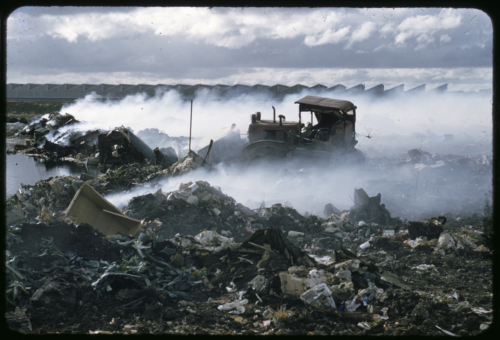
That is not what it looked like a couple decades later. By the time the Maribyrnong struggled to the sea, it was so choked with filth and silt it was a trickle. The swamp was catching all the city’s garbage like a whale catching krill.
A bit further south of the docks, on the east bank — you can just see the buildings from here, they look like big white tubs — that’s Coode Island, the chemical storage facility. I always wondered why Coode Island was called that: it’s not an island. But, it turns out it used to be.
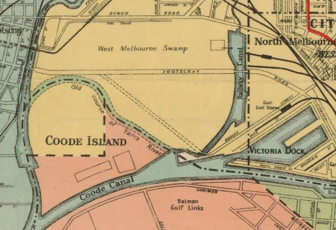
These days, the Maribyrnong River meets up with the other Melbourne river, the Yarra, near the ocean, just a little south of here, about a kilometre or two. The course of the Yarra used to be quite different.
In the 1870s, the Yarra was rerouted to make it more accessible for shipping. But the original course of the Yarra was still there, and between the new canal and the old Yarra, Coode Island was cut off from the mainland. The old Yarra’s been filled in now, but there were traces of its presence up until about the 1960s.
The original meeting of the Yarra and the Maribyrnong was right near the top tip of Coode Island, right about… here.
Salt
I’m not far from where I started, just a block or two south, near the Shepherd Bridge. The fork in the river that was once here, the point where the Yarra and the Maribyrnong met and parted, was, it turns out, the initial reason for what has proven to be Melbourne’s most enduring class divide.
Growing up in the Western suburbs gives you a bit of a chip on your shoulder. You’re used to being mocked, and it makes you defensive. Footscray is a bit gentrified now, a bit trendy, but when I was growing up here in the 90s, it was definitely not cool.
I remember when I was eight or nine, a kid from another area confidently declared that Footscray smelled bad. And I was furious, but I was also baffled. Footscray smelled pretty much like everywhere else in Melbourne, as far as I could tell. I concluded that the smell she was talking about was a metaphorical smell, the smell of low class.
And that was a pretty good piece of amateur sociological analysis, but it turns out that people have been saying Footscray smells bad for generations, and for most of that time Footscray smelled terrible.
In 1882, Footscray was at peak smelliness. People used to call it Worst Smellbourne. That was also the year the Footscray Rowing Club won the Clarke Challenge Cup, a major national championship on their own home practice river of Maribyrnong. The locals went wild. The rivals were people from rich places like Toorak who practised on the Yarra. It was a victory for the whole township.
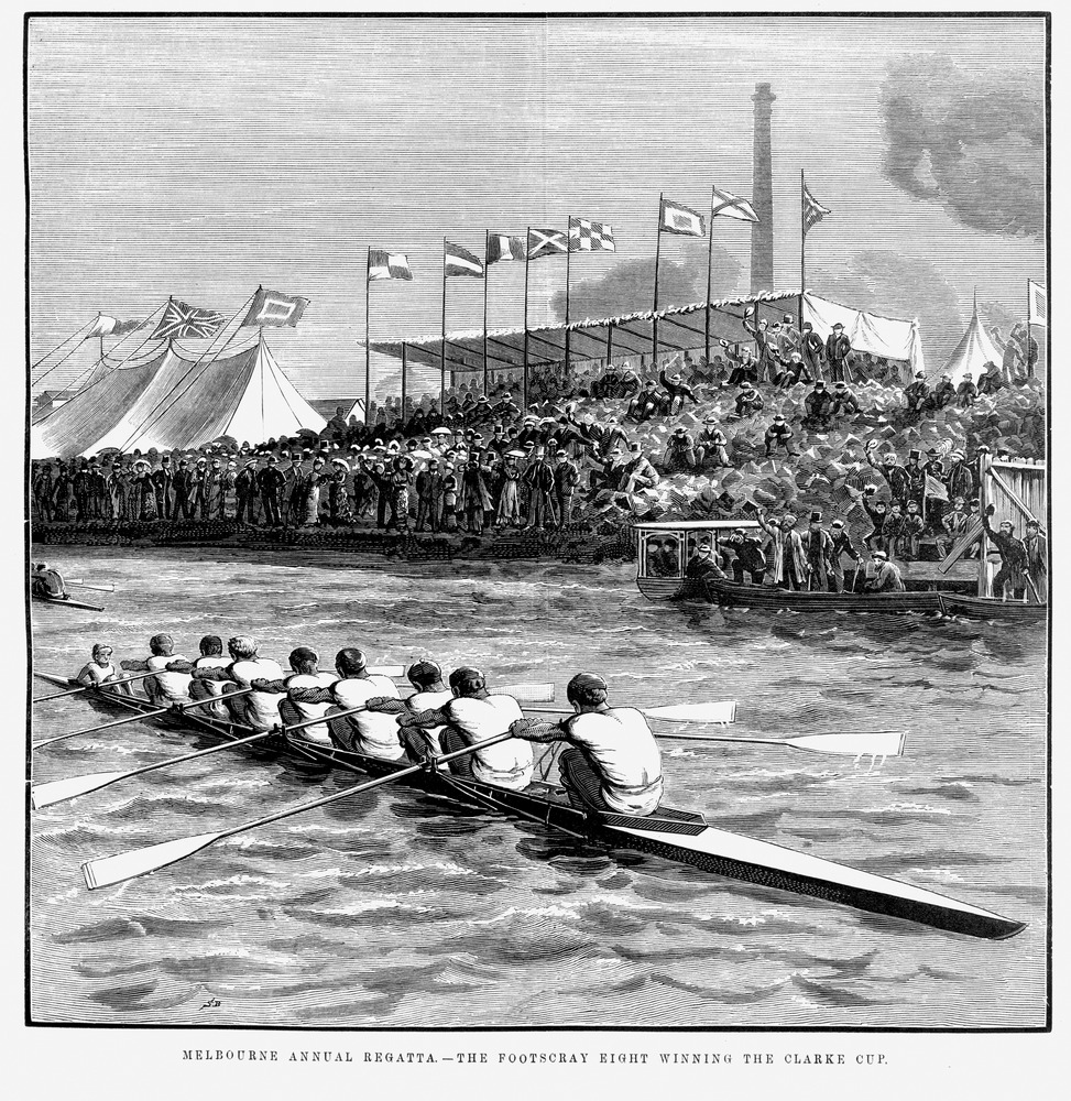
Visitors were less enthralled with the event, mainly because they kept getting splashed with blood and fat and chunks of rotting flesh in the river. A few years later, the regatta was moved to Albert Park Lake.
Footscray people complained bitterly and accused the regatta crowd of being a pack of sooks. On the face of it, that’s absurd. Not wanting to get splashed with rotting entrails is not exclusive to the aristocracy.
But if that seems absurd, so does this: after winning the championship in 1882, Footscray was disqualified from advancing, because too many of the squad were manual workers. It was judged that having to be strong for your job made you basically a professional athlete, and it was an amateur competition. Hence, disqualification. Thus, the dominance of the upper classes in the sport of rowing was assured.
So when the rowing authorities rejected the smells of the Maribyrnong, it was in a context where they’d already rejected the people of Footscray. They had punished them for daring to excel at something the upper classes had decided was theirs. The smell in this case was real, but it was still, also, a metaphor for disgust and contempt for the working class.
Why was the Maribyrnong so polluted, anyway? The reason that’s usually given is that in 1867, the Public Health Act was amended to provide stronger protections for Melbourne’s drinking water. Freshwater rivers and lakes, like the Yarra, were protected. The Maribyrnong River mingles with the sea for quite a way upstream, so it wasn’t protected: it’s too salty, it’s not drinkable. What were called the “noxious industries” — anything smelly, anything polluting, anything with toxic runoff — had to relocate to the Maribyrnong if they wanted access to a river. And they did want access to a river. Rivers are transport routes, they’re infrastructure, and as we’ve seen, they’re a waste disposal route.
It’s definitely true that the Public Health Act led to a lot of heavy industry relocating to the Maribyrnong River. By 1871 one third of the noxious trades in Melbourne were located on the Maribyrnong, and by 1888 half were.
It’s also true that the Yarra was originally a source of drinking water. That’s why the oldest parts of Melbourne are all on the Yarra, including the most wealthy and exclusive suburbs — that was the location the very first British colonial survey recommended in 1803. The Yarra and the Maribyrnong are called the Freshwater and Saltwater River in early documents from that survey. The Freshwater River was quickly renamed the Yarra based on what settlers believed to be its Wurundjeri name. The Saltwater River kept that placeholder name, that marker of its lesser value, until 1913.

Here’s the thing, though: by the time the pollution of the Maribyrnong was at its worst, in the late 19th century, the Yarra was no longer a freshwater river. In 1883, civil engineers blew up the little waterfall that used to prevent seawater coming back up the Yarra. They decided they didn’t like it anymore, it was too much of a flood risk. And given that the Yan Yean reservoir had been finished in 1853 and most people who lived in Melbourne were getting water piped in from there, nobody was actually getting their drinking water from the Yarra anymore — or at least, nobody who mattered.
So initially, sure, maybe the fact that the Yarra was protected and the Maribyrnong wasn’t was about the Yarra being fresh and the Maribyrnong being salt. But I think another reason, and certainly the reason things stayed that way, was class. Protecting the Yarra was about protecting Melbourne’s wealthy from the smells of the noxious industries, pushing them off to what was then the fringe of the city.
People in Footscray did try and fight industrial pollution. But the factory owners pushed back with the narrative that if you loved Footscray’s people, you loved its smells. They framed themselves as job creators, pioneers of Footscray, pillars of the economy, and they stacked out the council and the local media. If you didn’t want to smell rotting meat all day, you were a Toorak toff, a fancy boy.
It was pretty unpleasant to learn about this because I realised, had I been around at the time, that incredibly cynical PR strategy would have totally worked on me. I used to say I personally wouldn’t care if the whole planet got paved over. I knew it would be a bad idea, I just couldn’t relate to the environmentalists I met — they seemed like annoying hippies who loved “forests” and hated “heavily polluted post-industrial regions”. And when I first became interested in industrial history, it was because it made me feel at home, it made me feel more connected to my family and my community. But so many people in my family and my community have been hurt by industrial accidents and poisonings and disease. They played me like a fucking fiddle.
And things aren’t that different today. You know how people used to complain endlessly about the smell of the boiling-down works, the works that made tallow? They still do. The Australian Tallow Industries factory is one of the most repeated violators of EPA air quality regulations in the state. And they are located just next door to Cedar Meats — the meatpacking plant that was recently identified as the central node of over 100 coronavirus infections.
That slaughterhouse complex is in the suburb of Brooklyn, about six kilometres from where that kind of thing used to be in Footscray. The past is never really past, just elsewhere, in a slightly cheaper postcode.
Outro music is ‘What’ll we do when this is over?’, composed by Jack Davey and performed by Al Royal and Nicholas Robins at the Arcadia Theatre, Chatswood NSW, circa 16 December 1942.
References
Sources cited (Meat)
Melbourne Meat Processing Works, Saltwater River, photograph, c. 1872.
“Out in a Gondola, At Low Water.” Independent (Footscray), 27 Aug 1887.
“Swamp Road Canal.” Independent (Footscray), 29 Oct 1887.
“The Swamp Road, to be known in future as Dynon Road.” Independent (Footscray), 14 Mar 1903.
Footscray waterfront from Hopkins St Bridge, photograph from the Rose Series, c. 1920-1955.
Boiling down sheep in Australia [woodcut] / J.M. 1868.
“The Boiling-Down Establishment at the Saltwater River.” Independent (Footscray), 27 Feb 1868.
Boiling down sheep in Australia [woodcut] / J.M. 1868.
More (Meat)
A History of Footscray by John Lack is referred to for background throughout.
Out in a Gondola, At High Tide. Independent (Footscray), 20 Aug 1887.
The Royal Sanitary Commission. The Age, 4 Jul 1888.
The Sanitary Commission. First progress report. The Argus, 20 Apr 1889.
Melbourne’s Living Museum of the West. “Footscray Wharves and Environs.” 2017.
Gary Vines, 1990. Industrial Heartland: Introduction to the Western Region Industrial Heritage Study. Melbourne’s Living Museum of the West.
Maribyrnong Historic Places Study (2000-2001):
Volume 3 – Industrial places in the City of Maribyrnong.
Volume 5 – Urban conservation areas and individual places in the former City of Footscray.
Sources cited (Swamp)
View from Flagstaff Hill, West Melbourne, in 1841. Ashton, Julian Rossi. Engraved 1881.
Still Here, a brief history of Aboriginal People in Melbourne’s West. Living Museum of the West, 1996; particularly panel 3, Invasion.
“Out in a Gondola, At Low Water.” Independent (Footscray), 27 Aug 1887.
The Filling of the Bay – The Time of Chaos. Boon Wurrung story told by Aunty Carolyn Briggs.
“Port Phillip Bay once high and dry”. Stuart Gary, ABC Science News, 14 April 2011.
“10,000-year bay theory doesn’t hold water”. Stephen Cauchi, The Age, May 8, 2011.
The erasure of Melbourne’s wetlands. Sarah Matthews. State Library of Victoria blog, August 29, 2016.
West Melbourne Swamp. John Lack for eMelbourne.
Walking the blue lake. David Sornig. State Library of Victoria blog, April 16, 2019.
Bulldozers at work, West Melbourne swamp. Photograph, c.1960-3.
Industrial: Coode Island. Melbourne, Victoria, Australia, August 1991. Australian Disaster Resistance Knowledge Hub.
Melbourne and suburbs map by Department of Lands and Survey, 1935.
More (Swamp)
Interview: Boonwurrung Elder Carolyn Briggs. Culture Victoria. Accessed 26/06/2020.
Gary Vines with Brett Lane, 1994. Industrial Land And Wetland: The relationship between the natural environment and industrialization in Melbourne’s Western Region. Melbourne’s Living Museum of the West.
Sources cited (Salt)
A ‘dirty moleskin crowd’: The Footscray rowing eight, amateurism and the manual labour issue at the annual Melbourne Regatta, 1880-1886. Darren Arthur, 2018. Sporting Traditions, v.35.
Melbourne Annual Regatta — the Footscray Eight Winning the Clarke Cup. Woodcut, Bennett, S. Melbourne : David Syme and Co., March 12, 1881.
An Act to amend the Laws relating to or affecting Public Health. 6th September, 1867.
“THE VOYAGE OF HIS MAJESTY’S COLONIAL SCHOONER “CUMBERLAND,” FROM SYDNEY TO KING ISLAND AND PORT PHILLIP IN 1802-3.” A Journal of the Exploration of Charles Grimes, Acting Surveyor-General of New South Wales. Kept by James Flemming.
Grimes’ survey map of Port Phillip Bay, 1803 (1879 facsimile).
Plan of valuable building sites, at West Melbourne, 1859.
The Yarra below the Falls. State Library of Victoria.
Removal of the Yarra Falls. The Argus, 24 May 1883.
Yan Yean Water Supply, Victorian Heritage Database report.
“Rendering company found guilty for rotting carcass smell.” EPA Press release 25 Nov 2015.
Goya Dmytryshchak. “Australian Tallow Producers fined again by EPA.” Maribyrnong and Hobsons Bay Star Weekly, 14 May 2019.
Matilda Boseley. “Worksafe investigates coronavirus cluster at Cedar Meats as workers speak out.” The Guardian (AU), 13 May 2020.
Rachel Eddie. “Victoria’s largest COVID-19 cluster grows with three new Cedar Meats cases.” The Age, May 21, 2020.

Very good read, my great grandfather ran a sausage casing works in Swamp road Footscray 1887. Exported to Europe . I’ve been trying to find Swamp road for my historical research, your article has helped find my family history. He lived not far from Swamp road and lost three of his young family to disease in these early years.
Great story Jinghua. Good to see the social context of Melbourne’s historic class divide and industrial history recognised. Just as an aside, you might have seen the excavation works for the new Westgate Tunnel project on the edge of the Maribyrnong. This revealed layers of rubbish fill and a black muck that I suspect was the rotted slaughterhouse waste. Directly beneath this was a peaty layer that formed the original base of the swamp. Batman’s Swamp is still there, its just covered over by the detritus of humanity.
Another spot you might be interested in looking at is Newells Padock. This was once the holding paddock for livestock heading to Angliss Meatworks where “everything from the sheep was used but the bleat”. The stock bridge over the river was once a footbridge at the bottom of Punt Road. It was moved here when the new Hoddle Street Bridge was built, and relocated here to avoid cattle and sheep having to be herded down Geelong Road. The Drovers from the Newmarket Saleyards used to lead livestock down to Angliss’, Borthwick’s, Smorgan’s, Ralph’s and other meatworks in the evening to avoid the traffic. The Living Museum has oral history interviews with some of the drovers, slaughtermen, auctioneers and stock and station agents who once inhabited this area.
Newells Paddock became a land reclamation area when dredging was carried out along the Maribyrnong. Layers of congealed fat a metre thick were sucked up and spat out to fill the swampy land. This reminder of the area’s industrial history was briefly exposed when the artificial wetlands were created in Newell’s Paddock.
anyway, love your work, Keep it up.
PS, you might have already seen it, but it wasn’t in your references, so I recommend “The Outcasts of Melbourne : essays in social history” edited by Graeme Davison, David Dunstan, Chris McConville https://trove.nla.gov.au/work/12862973
Love this.
Fascinating.
I grew up in west footscray, and I remember the smells from the cattle yards wafting over from Kensington to footscray. Not nice.
Thank you, this was a very good listen.